Difference between revisions of "Argot"
| Line 10: | Line 10: | ||
ArgotPlus is being actively developed with many more featured planned. | ArgotPlus is being actively developed with many more featured planned. | ||
| − | == The bookmark list == | + | == Features == |
| + | |||
| + | Some features only available in ''ArgotPlus''. | ||
| + | |||
| + | === The bookmark list === | ||
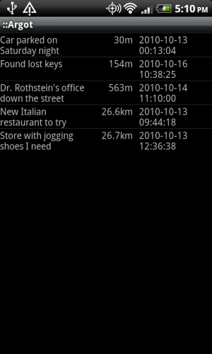
[[Image:argot.list-screen.png|thumbnail|right||The main list of bookmarks]] | [[Image:argot.list-screen.png|thumbnail|right||The main list of bookmarks]] | ||
| − | The bookmark list can be sorted by either the bookmark name, the bookmark's proximity to your current location, or the date and time that the bookmark was created. Measurements can be displayed in either metric or English units. | + | The bookmark list can be sorted by either the bookmark name, the bookmark's proximity to your current location, or the date and time that the bookmark was created. Measurements can be displayed in either metric or English units. When bookmarks are sorted by proximity, the [http://en.wikipedia.org/wiki/Cardinal_direction cardinal direction] (north, south, east, or west) is displayed for each (''ArgotPlus''). Bookmarks in the list can be filtered by any combination of tags (''ArgotPlus''). |
| + | |||
| + | Settings: | ||
| + | |||
| + | * Sort column | ||
| + | * Filter tags (''ArgotPlus'') | ||
| + | * Units of measurement - Used for distance to each bookmark | ||
| + | * Timeout accuracy, Location timeout - When sorting by proximity, used to limit how long to wait for an accurate GPS reading before calculating bookmark distances | ||
| − | == The navigation screen == | + | === The navigation screen === |
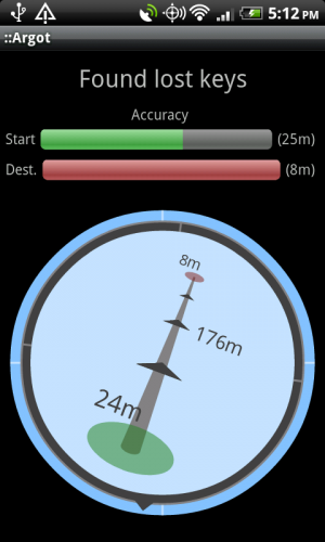
[[Image:argot.navigation-screen.png|thumbnail|right||The navigation screen]] | [[Image:argot.navigation-screen.png|thumbnail|right||The navigation screen]] | ||
The navigation screen displays the direction and distance of the bookmarked location, along with the accuracy of the GPS signal of both the bookmark (when it was saved) and your current location. | The navigation screen displays the direction and distance of the bookmarked location, along with the accuracy of the GPS signal of both the bookmark (when it was saved) and your current location. | ||
| + | |||
| + | Settings: | ||
| + | |||
| + | * Units of measurement - Used for start and destination accuracy, and distance | ||
| + | |||
| + | === The edit screen === | ||
| + | |||
| + | The edit screen allows you to set the name, set the GPS location, view the GPS accuracy, set tags (''ArgotPlus''), and view neighboring bookmarks (''ArgotPlus''). | ||
| + | |||
| + | Settings: | ||
| + | |||
| + | * Units of measurement - Used for bookmark GPS accuracy | ||
| + | * Neighbor distance (''ArgotPlus'') - Used to determine maximum distance between bookmarks to make them neighbors | ||
| + | * Minimum accuracy, maximum accuracy - Used to define the range represented in the accuracy progress bar | ||
| + | |||
| + | === The tag screen (''ArgotPlus'') === | ||
| + | |||
| + | The tag screen allows you to add and delete bookmark tags. Tags can be used singly or in combinations to filter a long list of bookmarks (e.g. filter by <code>#restaurant</code> and <code>#work</code>). | ||
== FAQ == | == FAQ == | ||
Revision as of 05:38, 11 November 2010
Argot (pronounced 'are-go) is a free Android application that allows you to bookmark locations using GPS. The bookmarks can then be organized and used for small-scale navigation (e.g. finding your car in a parking lot, or marking a meetup location in an unfamiliar neighborhood).
ArgotPlus is the pay version that allows you to import you existing bookmarks and adds the following features:
- Add custom Tags to bookmarks and filter the bookmark list by tags.
- View bookmarks that are in the neighborhood of another bookmark.
- Open the map for a bookmark's location.
- Display the relative direction of each bookmark in the bookmark list.
ArgotPlus is being actively developed with many more featured planned.
Contents
Features
Some features only available in ArgotPlus.
The bookmark list
The bookmark list can be sorted by either the bookmark name, the bookmark's proximity to your current location, or the date and time that the bookmark was created. Measurements can be displayed in either metric or English units. When bookmarks are sorted by proximity, the cardinal direction (north, south, east, or west) is displayed for each (ArgotPlus). Bookmarks in the list can be filtered by any combination of tags (ArgotPlus).
Settings:
- Sort column
- Filter tags (ArgotPlus)
- Units of measurement - Used for distance to each bookmark
- Timeout accuracy, Location timeout - When sorting by proximity, used to limit how long to wait for an accurate GPS reading before calculating bookmark distances
The navigation screen displays the direction and distance of the bookmarked location, along with the accuracy of the GPS signal of both the bookmark (when it was saved) and your current location.
Settings:
- Units of measurement - Used for start and destination accuracy, and distance
The edit screen
The edit screen allows you to set the name, set the GPS location, view the GPS accuracy, set tags (ArgotPlus), and view neighboring bookmarks (ArgotPlus).
Settings:
- Units of measurement - Used for bookmark GPS accuracy
- Neighbor distance (ArgotPlus) - Used to determine maximum distance between bookmarks to make them neighbors
- Minimum accuracy, maximum accuracy - Used to define the range represented in the accuracy progress bar
The tag screen (ArgotPlus)
The tag screen allows you to add and delete bookmark tags. Tags can be used singly or in combinations to filter a long list of bookmarks (e.g. filter by #restaurant and #work).
FAQ
This is an issue with any application, such as basic compass apps, that relies on the phone's magnetic field sensor. The YouTube video Best Compass Calibration Method (iPhone/G1/etc.) provides simple instructions on how to calibrate that sensor in your phone.

